


New
Arrivals/Restock

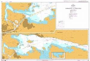
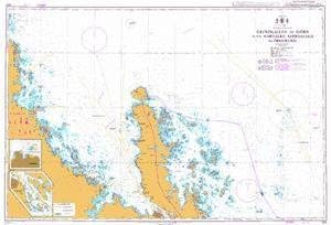
Pensacola, FL & Mobile Bay, AL - Laminated Nautical Navigation & Fishing Chart by Captain Segull's Nautical Sportfishing Charts | Chart # PM47

 4.5 (69 items)
 Limited Time Sale
Until the end
02
21
19
$16.77 cheaper than the new price!!
Free shipping for purchases over $99 ( Details )
Free cash-on-delivery fees for purchases over $99
Free cash-on-delivery fees for purchases over $99
See all stores
Please note that the sales price and tax displayed may differ between online and in-store. Also, the product may be out of stock in-store.
New $27.95
Product details
| Management number | 217818037 | Release Date | 2026/05/03 | List Price | $11.18 | Model Number | 217818037 | ||
|---|---|---|---|---|---|---|---|---|---|
| Category | |||||||||
Nearshore Fishing Chart: A nearshore chart 20 to 30 miles off the shore. Side A: from Wynne Haven Beach west to Romar Beach, includes Santa Rosa Sound, Pensacola Bay and Perdido Bay. Side B: from Romar Beach west to Bayou La Batre, includes all of Mobile Bay and an inset of the Mobile Ship Channel northern end Double sided laminated fishing Chart. Shows fishing areas, wrecks, reefs, local names and amenities in GPS out to the thousandths of a minute. 19.5" x 26.5"
- Laminated Fishing Chart
| Size | 19.5" x 26.5" |
|---|---|
| Color | waterproof laminated |
| Brand Name | Captain Segull's Sportfishing Chart |
| Part Number | PM47 |
| Manufacturer | Captain Segull's Nautical Charts, Inc |
Bestseller ranking
Leg Warmers


Customers who viewed this product also viewed
Charts & Maps


Correction of product information
If you notice any omissions or errors in the product information on this page, please use the correction request form below.
Correction Request Form